Hingham Harbor waters are protected from the weather by the hills of World’s End and Crow Point creating an attractive setting for Settlers from England beginning in 1633 at what was then known as Bare Cove. The Town of Hingham was incorporated in 1635. In that year there was a drawing for house lots, with early settlements extending from the harbor along Town Brook on the Town Street, now North and South Streets and to Broad Cove Lane, now Lincoln Street. Through the years the harbor area has emerged through periods of exploration, manufacturing and trade, industry, commerce, and now, recreation.
Wooden sailing ships were built at inner harbor shipyards in the 17th through 19th century using expertise and resources found throughout the town of Hingham. The Hingham fishing industry began in earnest about 1750 when Captain Francis Barker created the first shipyard at the harbor, at the foot of Ship Street. Fishing companies were soon formed. In the 19th century, mackerel was the primary fish sought by Hingham fishing schooners. 450 men were directly employed. The industry also supported local work in ship building and outfitting, sail, mast and spar, pump and block, and cordage production, in barrel coopering, and at salt works. In the 19th century Hingham’s inner harbor was transformed into a place for steamship wharves, and industrial uses such as a coal wharf, and an iron foundry.
In the 19th and early 20th centuries, steamboat wharves became part of Hingham’s busy Inner Harbor. The steamboat EAGLE, transiting between Hingham and Boston, began with seasonal service between 1818 and 1821. The ship could accommodate 200 passengers to/from Boston initially for about a 2-hour passage. Later ships, such as the GENERAL LINCOLN, shortened the trip to about 1 1/4 hours.
The 20th century then brought highway oriented commerce to the harbor.including car dealerships and gas stations.
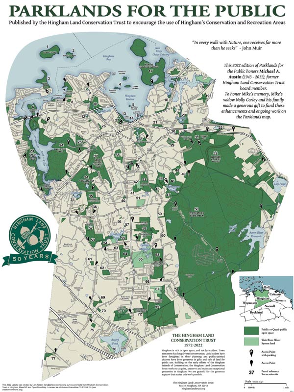
Today the Harbor is a place for recreation. The Town of Hingham owns 13.7 acres of park with scenic views of Hingham Harbor. There are three parking lots, one of which seasonally accommodates an open-air farmers’ market. The parks have a boat ramp, a mooring area and a bathing beach with a seasonal bath house and rest rooms. There’s a bandstand for entertainment and an open field for play. For light dining there’s a coffee shop and a seasonal snack bar as well as a grove with a picnic area and nearby restaurants.
Adjoining the bathing beach area, there is a launch ramp for boats and a dredged basin for mooring pleasure craft. The Iron Horse statue, also Known as the “Victory” statue, was installed in 1929 to honor townsmen who had served in the Armed Forces. Nearby Whitney Wharf was long used for commercial shipping. The site of a car dealership before being acquired in a land swap in 1989, it was then structurally restored and landscaped. The POW-MIA Veteran’s Park lies east of Whitney Wharf. The site, purchased by the town in 2009, further enhanced harbor views and access. The site also has a number of plantings, including linden trees along the parking lot edge. A bench that affords a view of the water bears a memorial designation.
The 0.8 mile Hingham Harbor Walk begins at The Beach House parking lot at 95 Otis Street. The route loops around the street-side of the treed lawn at the west end of the waterfront. At the west end of the lawn the route turns right onto a brick sidewalk which heads east along the waterfront. On the left are a low fence and shrubs with views of Hingham Harbor beyond. On the right are benches and picnic tables in the tree covered lawn. On the left of the walkway is a panel board with information on the late 18th and early 19th century history of Hingham’s Mackerel Fishing Industry. At the end of the field on the right is a white building followed by the parking lot. On the left is an opening over a sand dune flood barrier to the Hingham Bathing Beach. The route turns left onto the beach and continues right along the beach with harbor views on the left. On the right, the walk passes the parking lot, a lawn area with a band-stand lawn, and a second parking lot.
At the end of the beach the route crosses the Town Boat Ramp and into Iron Horse Park also known as Victory Park. In the park, the route continues across a short stretch of sand to an earthen wharf enclosed by stone retaining walls. The route crosses a short stretch of lawn to a path with an information panel on the far side of the path. The panel presents information on Hingham’s wooden sailing-ship building from the 17th through the 19th century. On the left of the panel on a hill in the middle of the wharf is an iron statue of a man on a horse. At the base of the hill the statue’s dedication to the memory of prisoners of war and military missing in action is described.
The route turns left on the walk following the wharf toward the harbor, then turns right. At the next corner the route passes the Town Landing, leading to floating docks, on the left. The route passes the harbormaster’s shed on the right and turns right into a parking lot. The route follows Town Brook on the left, towards Otis Street and turns left up a ramp. There is another ramp on the left down to Bare Cove Marina and Redeye Coffee Roasters and marina offices on the right. The ramp leads to a bridge which crosses Town Brook and connects to Whitney Wharf Park. The stone and earthen wharf has a garden with a lawn and plantings in the middle and a paved walkway with a railing at the edge of the wharf. There are benches along the edge of the garden for resting and enjoying water views. The route continues left (clockwise) along the walkway, with Town Brook on the left. At the harbor end of the walk the route turns right to a large compass set in stone in the ground. There is also another historic panel. This one is about Hingham’s lumber industry, which took advantage of the abundant supply of local lumber to support foreign trade. Turning right toward Summer Street the walk leads to the inland end of the wharf and onto a walkway and parking lot on the left. The walk passes benches then turns right and left onto a paved walkway into lawn covered POW/MIA Memorial Park. There is a tree covered lawn to the right of the walkway and harbor views to the left. The walkway ends in a short distance at a bench with another information panel on the left. The panel describes the history of passenger steamboats between Hingham and Boston in the nineteenth and early twentieth centuries. Continuing east with the harbor on the left, the route goes through a tall hedge. There is an open field between Summer Street on the right and the edge of the harbor on the left providing more harbor views. This field is the end of the continuously connected harborside parks. The walk route now turns back towards the Beach House parking lot.
The route goes parallel to the Summer Street sidewalk across the open field, the lawn of the POW/MIA Memorial Park and the parking lot to Whitney Wharf Park. At the street end of the park’s garden on the right side of the walkway are an anchor and flags. On the left is a plaza made of donor bricks with inscribed dedications. There is also another panel with the history of the evolution of Hingham’s Waterfront from settlement to current times. The route continues to the right on the wharf with Town Brook on the left. Turn left onto the bridge across Town Brook past Bare Cove Marina and Red Eye Roasters. Benches provide an opportunity to enjoy a snack from Red Eye Roasters and views of the water. Continue down the ramp and across the parking lot to the chain-link fence to the right. Beyond the end of the fence turn left into Iron Horse Park. Walking parallel to the fence, cross the walkway in the park and exit the park at the right end of the facing chain link fence. The route crosses the Town Boat Ramp to the near end of the beach next to the parking lot then continues along the beach parallel to the parking lot. At the end of the parking lot the route turns left away from the beach and right onto the walkway between the beach and the bandstand lawn area. The route continues along the walkway with the beach dunes on the right and the bandstand lawn on the left. The route turns left onto a walkway that leads to the Beach House. At the beach house there are public restrooms. The Beach House Bistro also offers ice cream and other take-out snacks. After a visit to the Beach House the walk is complete.

Recommended Trail Activities: Running, Walking Length: .8 Route Type: Path (Medium) Difficulty (Grade/Surface): Easy Parking: Adequate Dog Restrictions: Allowed Ancillary Activities: Snowshoeing, Birding, Boating, Fishing (license may be required), Picnic, Historic Sites

