Parklands for the Public Map


Explore
PARKLANDS FOR THE PUBLIC MAP
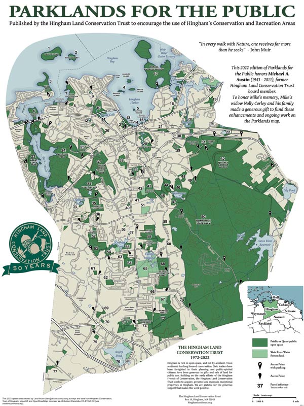
This 2022 edition of Parklands for the Public honors Michael A. Austin (1943 – 2011), former Hingham Land Conservation Trust board member. To honor Mike’s memory, Mike’s widow Nolly Corley and his family made a generous gift to fund these enhancements and ongoing work on the Parklands map.
“Parklands for the Public,” a map of open space and recreational areas in Hingham, is published by HLCT to encourage exploration and enjoyment. This map and appropriate clothing are all that is needed to get some fresh air, exercise and learn something interesting about our beautiful town.
This seventh edition builds on the work of others over fifty years. In 1970, the Hingham Conservation Commission published a charming freehand map of Open Areas in the Town of Hingham including 21 open space areas. In 1982, Phil Swanson, Francis Wylie and John Richardson produced the first HLCT “Parklands for the Public” map, including descriptions of 65 open space parcels. The map was revised and reissued in 1985 for Hingham’s 350th anniversary, again in 1995, 2003, 2010 (for Hingham’s 375th anniversary), and 2017. In addition to some property updates, this 2022 edition brings the map into the modern era by digitizing the map so that it is more accurate and will allow for future enhancements such as allowing users to zoom in on specific areas to see details such as trails and being interactive when accessed on a mobile device. The numbers on the map are linked to the individual, contiguous, or associated groups of properties described on the back. The 77 numbered text descriptions now cover more than 90 individual open space parcels.
Hingham has changed in many ways since 1982. Much open land has been lost to development, but much has been preserved: notably, Turkey Hill; Weir River Farm; Triphammer Woods; a 100-acre addition to Wompatuck Park; the South Shore Country Club; and the Town’s acquisition in 2017 of the 50-acre Lehner property. The Lehner property acquisition is the most valuable land conservation project since the town adopted the Community Preservation Act (CPA) in 2001. From 2003 to 2017, 13 parcels were purchased, after Town Meeting approval, with CPA funds. Additional open space has been acquired through land donated to the Town. We have preserved some notable examples of Hingham’s landscape heritage: expansive coastal views, ponds set in idyllic woods, rolling pastoral fields and meadows. Many of the preserved open spaces and wetlands contribute in important ways to the health of our watershed and of birds, insects and other wildlife.
Printed Poster
HLCT members may obtain a poster-size copy of the map by mail by requesting it when sending a donation, or by using the “Contact” form on this website. The map is also available upon request at the Hingham Conservation Commission at Town Hall.


